![](/images/other/stat-length.png)
![Tocht Stappen Kastelruth - Castelrotto - Seiser Alm - Refuge Tierser-Alpl - Photo](https://media.geolcdn.com/t/1900/400/34c4e879-96cb-4fe3-9167-5cbcfd706503.jpg&format=pjpeg&maxdim=2)
Seiser Alm - Refuge Tierser-Alpl
VacheKiri67
Gebruiker
![Lengte](/images/other/stat-length.png)
![Max. hoogte](https://static1.geolcdn.com/siteimages/upload/files/1508320355ic_sort_altitude_max_24dp.png)
![Positief hoogteverschil](https://static1.geolcdn.com/siteimages/upload/files/1508320355ic_sort_den_pos_24dp.png)
![Km-Effort](/images/other/stat-length.png)
![Min. hoogte](https://static1.geolcdn.com/siteimages/upload/files/1508320355ic_sort_altitude_min_24dp.png)
![Negatief hoogteverschil](https://static1.geolcdn.com/siteimages/upload/files/1508320355ic_sort_den_neg_24dp.png)
![Boucle](https://static1.geolcdn.com/siteimages/upload/files/16400158638029165_repeat_loop_refresh_sync_direction_icon.png)
![Stappen](https://static1.geolcdn.com/sitytour/trail-icons/101.png)
5h12
Moeilijkheid : Moeilijk
![Scan deze QR-code om de tocht te openen in de SityTrail-applicatie](https://capi.geolives.com/qq0zvz2zws4bq2lad0pu/sitytour/trails/3741301/qr.png?size=200)
Gratisgps-wandelapplicatie
Over ons
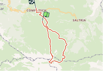
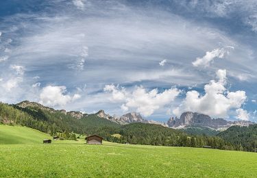
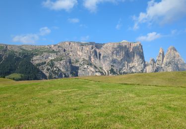
Tocht Stappen van 14,7 km beschikbaar op Trento-Zuid-Tirol, Bolzano - Bozen, Kastelruth - Castelrotto. Deze tocht wordt voorgesteld door VacheKiri67.
Beschrijving
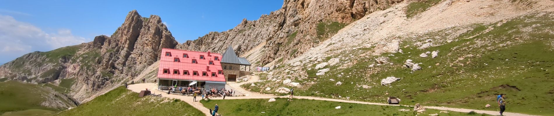
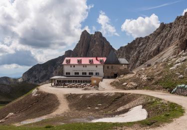
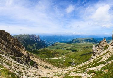
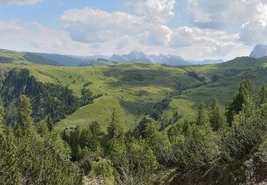
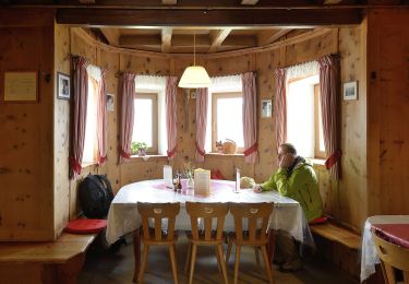
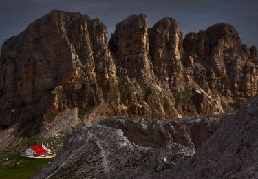
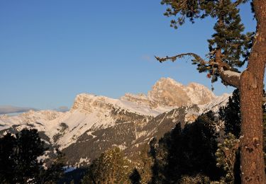
Faite le 20/07/2023. D'après "Rother : Dolomiten 1 - 39 Von der Seiser Alm zur Tierser-Alpl-Hütte". Durée indiquée pour le circuit : 4h30. Montée au Seiser Alm depuis Seis par la télécabine Kompatch, puis prendre le télésiège Panorama. La randonnée est difficile car longue et la montée en lacets à la Roszahn-scharte est rude ! Bonnes chaussures indispensables.
Plaatsbepaling
Opmerkingen
Wandeltochten in de omgeving
![Tocht Te voet Tiers - Tires - (SI C19N) Rifugio Alpe di Tires - Rifugio Sasso Piatto - Photo](https://media.geolcdn.com/t/375/260/66860676-3d92-45ba-b11c-2a3a5c3b3ee3.jpeg&format=jpg&maxdim=2)
![Te voet Te voet](https://static1.geolcdn.com/sitytour/trail-icons/100.png)
Te voet
![](/images/other/stat-length.png)
![](https://static1.geolcdn.com/siteimages/upload/files/16400158638029165_repeat_loop_refresh_sync_direction_icon.png)
![Tocht Te voet Völs am Schlern - Fiè allo Sciliar - (SI C18N) Rifugio Bolzano - Rifugio Alpe di Tires - Photo](https://media.geolcdn.com/t/375/260/2b3b6c37-933d-47c7-866c-9c42000bd74c.jpeg&format=jpg&maxdim=2)
![Te voet Te voet](https://static1.geolcdn.com/sitytour/trail-icons/100.png)
Te voet
![](/images/other/stat-length.png)
![](https://static1.geolcdn.com/siteimages/upload/files/16400158638029165_repeat_loop_refresh_sync_direction_icon.png)
![Tocht Te voet Kastelruth - Castelrotto - IT-5 - Photo](https://media.geolcdn.com/t/375/260/e1cc7a5e-e3cd-4887-a2e9-4c1bceaace35.jpeg&format=jpg&maxdim=2)
![Te voet Te voet](https://static1.geolcdn.com/sitytour/trail-icons/100.png)
Te voet
![](/images/other/stat-length.png)
![](https://static1.geolcdn.com/siteimages/upload/files/16400158638029165_repeat_loop_refresh_sync_direction_icon.png)
![Tocht Te voet Völs am Schlern - Fiè allo Sciliar - Touristensteig - Photo](https://media.geolcdn.com/t/375/260/57dc983a-b6a5-4288-944f-8fea0f41275d.jpeg&format=jpg&maxdim=2)
![Te voet Te voet](https://static1.geolcdn.com/sitytour/trail-icons/100.png)
Te voet
![](/images/other/stat-length.png)
![](https://static1.geolcdn.com/siteimages/upload/files/16400158638029165_repeat_loop_refresh_sync_direction_icon.png)
![Tocht Te voet Tiers - Tires - IT-3A - Photo](https://media.geolcdn.com/t/375/260/7e833536-4413-4ec0-ad76-4f864228b8fe.jpeg&format=jpg&maxdim=2)
![Te voet Te voet](https://static1.geolcdn.com/sitytour/trail-icons/100.png)
Te voet
![](/images/other/stat-length.png)
![](https://static1.geolcdn.com/siteimages/upload/files/16400158638029165_repeat_loop_refresh_sync_direction_icon.png)
![Tocht Te voet Kastelruth - Castelrotto - IT-9 - Photo](https://media.geolcdn.com/t/375/260/4b38568f-e1b6-42b9-96cf-c08768c59a51.jpeg&format=jpg&maxdim=2)
![Te voet Te voet](https://static1.geolcdn.com/sitytour/trail-icons/100.png)
Te voet
![](/images/other/stat-length.png)
![](https://static1.geolcdn.com/siteimages/upload/files/16400158638029165_repeat_loop_refresh_sync_direction_icon.png)
![Tocht Te voet Tiers - Tires - IT-3 - Photo](https://media.geolcdn.com/t/375/260/82b14c05-de5c-47fe-8046-5b31989bef08.jpeg&format=jpg&maxdim=2)
![Te voet Te voet](https://static1.geolcdn.com/sitytour/trail-icons/100.png)
Te voet
![](/images/other/stat-length.png)
![](https://static1.geolcdn.com/siteimages/upload/files/16400158638029165_repeat_loop_refresh_sync_direction_icon.png)
![Tocht Te voet Kastelruth - Castelrotto - IT-2 - Photo](https://media.geolcdn.com/t/375/260/2b3b6c37-933d-47c7-866c-9c42000bd74c.jpeg&format=jpg&maxdim=2)
![Te voet Te voet](https://static1.geolcdn.com/sitytour/trail-icons/100.png)
Te voet
![](/images/other/stat-length.png)
![](https://static1.geolcdn.com/siteimages/upload/files/16400158638029165_repeat_loop_refresh_sync_direction_icon.png)
![Tocht Stappen Kastelruth - Castelrotto - Schlern - Photo](https://media.geolcdn.com/t/375/260/d36457a9-cdc8-4fc0-a59e-01709009d44d.jpg&format=jpg&maxdim=2)
![Stappen Stappen](https://static1.geolcdn.com/sitytour/trail-icons/101.png)
Stappen
![](/images/other/stat-length.png)
![](https://static1.geolcdn.com/siteimages/upload/files/16400158638029165_repeat_loop_refresh_sync_direction_icon.png)